Sunday, July 31, 2016

Burgess Shale

Trip Date: July 2016


"The Burgess Shale is not unique, but for those who study evolution and fossils it has become something of an icon. It provides a reference point and a benchmark, a point of common discussion and an issue of universal scientific interest." 
          ~Simon Conway Morris, Paleontologist

I spotted this Elk on my early morning drive to the trailhead. There were also two Pine Martens around the next corner, but they were both camera shy!
The trailhead for the hike is Takakkaw Falls, one of the tallest waterfalls in Canada. In the Cree language 'Takakkaw' means 'It Is Magnificent'; can't argue with that!

My shoulders were burning with the weight of my pack. Sweat was rolling down my face, stinging my eyes. My lungs were working overtime from the last steep push to the top. But even with all my bodily discomfort those final paces were significant as they followed in the exact footsteps of Charles Doolittle Walcott, the man responsible for discovering the Burgess Shale. The soreness seemed to just melt away as I caught my first glimpse of the famous fossil bed. My sole purpose for being 2,286 m (7,500 ft) above sea level, perched on the side of a mountain ridge was this exact spot; Walcott's legendary quarry. It took only a matter of seconds for my eyes to spot a lone fossil peeking out from among the broken shale and from that point I was hooked.

On the trail with Wapta Mountain in the background
The hike passes two sets of red Adirondack chairs, which are part of Parks Canada's Red Chair Program. The first set is near Takakkaw Falls, while these two are on the shoreline of Yoho Lake.
Yoho Lake with a superb view of Wapta Mountain
You can read all about the Red Chair Program by visiting the Calgary Guardian website and reading my story titled, Share The Chair.

The Burgess Shale has been called one of the most important fossil discoveries anywhere on the planet. The fossils found there are over 505 million years old and are some of the finest examples of soft-bodied preservation anywhere on Earth. Most fossils on record contain hard body parts, such as bones, shells, and teeth, but the ones discovered in the Burgess Shale also contain mineralized soft tissues allowing us to see the entire organism completely preserved. Half a billion years ago the geography that is now Yoho National Park was very different. There was no British Columbia, no Canada, not even a North America. The entire area was under the ocean and all life on our planet resided below the surface. The exceptional fossils of some bizarre looking creatures include some of the oldest known relatives of many species still alive today. These primitive creatures lived near the muddy sea floor. At different times these animals would be caught in underwater mudslides, becoming buried in deep water away from scavengers. The mud and silt that entombed them was so fine it was able to settle between each curve and crevasse of the organism's body. Additional layers of mud and silt were deposited on top, slowly flattening the entrenched animals. Over time and through various geological processes the mud and silt hardened eventually becoming shale; preserving the trapped inhabitants for eternity.


Our first view of the President Range with Emerald Glacier perched on the summit
Emerald Glacier
This Hoary Marmot was basking in the sunshine
Emerald Lake as view from our lunch spot
This Golden-Mantled Ground Squirrel was looking for handouts
A Golden Eagle soaring on thermal updrafts

Like champagne bubbles, Viagra, and Velcro, the Burgess Shale was also discovered accidentally. In the late 19th century as the Canadian Pacific Railroad (CPR) was moving westward through the difficult Kicking Horse Pass region, one railroad employee found what he described as "stone bugs" on the steep slopes of Mount Stephen. Those "bugs" turned out to be Trilobites and there were millions of them. The stories of the stone bugs eventually made their way to geologists from the Geological Survey of Canada (GSC), bringing scientists out west to study the site, collect specimens, and publish reports about their findings. One of those reports caught the attention of Walcott, a fossil enthusiast and Secretary of the Smithsonian Institution, although he didn't visit the famed Trilobite bed until 1907, a full 20 years after first reading about it. Two years after his initial visit Walcott was back in British Columbia in search of more fossils, but here's where history gets a little murky. While riding his horse on a high trail between Wapta Mountain and Mount Field, Walcott encountered a large rock in his path. He was either bucked off his horse or got off his horse to move the boulder out of the way. However he got off his horse isn't as important as what he discovered while on the ground. Had he not dismounted his horse that fateful afternoon the small fossil he found would have likely gone undiscovered awhile longer. That early specimen would become the first of many collected from Walcott's Quarry in the Burgess Shale, so whichever version of history you prefer, it was a defining moment either way. Walcott and his family would spend at least a portion of every field season in the Canadian Rockies from 1907 to 1924, uncovering new organisms, many of which were previously unknown to the scientific community. It was Walcott that determined the fossils were from the Middle Cambrian age, making them over half a billion years old. Throughout his time in the Rockies he would identify many new species and provide expertise on the area and its prehistoric organisms. By 1924 Walcott assumed he had exhausted his quarry and didn't return the next year. Unfortunately he died in 1927 leaving the 65,000 fossils he collected all but ignored for the next 40 years. Ultimately his collection would become one of the jewels of the Smithsonian Institution's permanent collections at the National Museum of Natural History in Washington, D.C.


Entering the restricted area, so we must be close!
The final push to the top. That's Mount Burgess on the right.
Sign marking the entrance to the quarry


At first glance Walcott's Quarry doesn't look like much, but hiding amongst all that shale are countless creatures just waiting to be discovered!
This is an example of a well-preserved Ottoia, a worm-like species that was carnivorous and lived in the sediment on the sea floor

Today the Burgess Shale is completely off-limits to the public; protected within the UNESCO Canadian Rocky Mountains World Heritage Site. Guided tours are offered throughout the summer by the Burgess Shale Geoscience Foundation and Parks Canada, which is how I ended up there. The hike itself is 22 kilometres round-trip with 800 metres gained in elevation. We were on the trail for 10.5 hours moving at a leisurely pace. The trail passes picturesque Yoho Lake, crosses Yoho Pass, and offers spectacular views of Emerald Lake and surrounding peaks, but the main attraction is definitely the fossil bed. Despite Walcott's assumption we know his quarry is still providing fossils to those with patience and keen eyesight. Easily the best part of the tour is digging through the shale in search of undiscovered prehistoric creatures, just as Walcott himself had done all those years ago. With a little luck you're sure to uncover critters not seen for many years, maybe ever!

How many fossils can you see in this photograph?
Here's an example of Vauxia, a type of sponge. Walcott named this creature after his third wife Mary Vaux.
These are the two almost complete specimens I found in the quarry. Both are most likely Olenoides as they're typically the most well-preserved Trilobites.

The statistics for the hike may seem daunting at first, but aren't actually that bad. Yes the hike is considered difficult. It's the equivalent of climbing all the stairs in a 234 story building both ways, but our guide did an incredible job of keeping a relaxed pace that included numerous stops for rest, water, and snacks. Throughout the day our guide entertained us with informative chats about the formation of the site, the history of the area, and the significance of the discovery. Our group of 12 ranged in age from as young as 19 up to and including retirees, all of whom safely completed the trek. We were treated to perfect hiking conditions complete with a blue bird sky and ample sunshine. We couldn't help but comment on the weather as the entire area has seen almost daily rain storms leading up to this tour.

An extremely well-preserved Trilobite fossil with Emerald Lake far in the background
Me standing in Walcott's Quarry holding a fossilized Trilobite
Mount Burgess (left) and Emerald Lake as viewed from the quarry
The smile on my face says it all!

We spent just over an hour in the quarry and that time passed by incredibly fast. I was able to find several fossils, including two Trilobites that appeared to be complete specimens. It's difficult to know for sure whether those fossils had previously been seen by human eyes. I like to think that I was the first to discover those small relics of the past, further deepening my newfound connection to Walcott. But before I knew it we were back on the trail, headed for home. There was a noticeable absence of conversation after leaving the quarry. Perhaps everyone was reflecting on the memorable experience or maybe the adrenaline had now subsided and we were left with the sudden realization that we had a long slog back to the trailhead. Whatever the reason for the silence this guided excursion had provided me with memories and photographs that would last a lifetime.


One final glace towards the Burgess Shale from the publicly accessible trail as we begin our descent

To reserve your spot on an upcoming guided hike to the Burgess Shale please visit the Yoho National Park website. You can also follow them on Twitter and Facebook in order to stay completely up to date with everything happening in the park. For an in depth look at the Burgess Shale, including a virtual submarine tour of the underwater community, please visit the Royal Ontario Museum website. In closing I'd like to thank Karin Smith for putting this whole trip together and Kristi Beetch, our remarkable guide, for getting all of us to the site and back safely while making the day engaging and meaningful. Thank you both!


The hike starts and stops at the same spot; Takakkaw Falls!

To read about my other forays into Yoho National Park please visit my previous blog posts titled,Yoho National Park: MonarchYoho National Park, and Emerald & Hamilton Lakes. You can also read this story in several other places including the Calgary Guardian (Yoho's Stone Bugs), and GOT Parks (Yoho's Stone Bugs).


Yoho National Park: Monarch

Trip Date: July 2016


After learning I had been accepted on to the Burgess Shale hike (it's so cool it deserves its own blog post!), Christine and I immediately planned a camping trip to Yoho National Park for the August long weekend. I was on holidays the week prior, but Christine had to work, so I headed to Yoho early Thursday morning to get us a campsite as all of the campgrounds within the park are first come first serve. Unfortunately the Kicking Horse Campground was already full, so we had to settle for Monarch Campground. It's quite nice, but there are two things that diminish its quality in my opinion; it's too close to the highway so there's a constant drone from all the traffic and campfires are not allowed. We'd stayed in Kicking Horse on a previous trip and really enjoyed it, so we were a little disappointed we couldn't get in, but that's how it goes on a busy long weekend.

While driving through Banff on my way to Yoho I spotted this Grizzly Bear near the road. Unfortunately there were dozens of tourists outside their vehicles trying to get photographs. I snapped these from the safety of my truck before leaving the scene and calling Banff's Wildlife Hotline.
Turns out this is Bear 136, also known as Split Lip, due to a large chuck missing from his upper lip. He's a 225kg dominant male that once killed and ate a a smaller Grizzly last year.
Campsite in the Monarch Campground
Colombian Ground Squirrel looking for scraps in our site 
The view from the site was pretty sweet!
After setting up camp and having lunch I headed for the Emerald Lake parking lot. I wanted to scout the lake for paddleboarding later in the weekend and also to go for a hike. I settled on Emerald Basin, a 9.2 km round-trip trek to a natural amphitheater surrounded by towering peaks. To access the trailhead you need to hike the first 1.4 kms of the Emerald Lake Shoreline Trail before accessing the 3.2 km trail to the basin. The basin trail gains 225 m in elevation.

Emerald Lake with Michael Peak (left), Yoho Pass (centre), and Wapta Mountain (right)
Mount Burgess as viewed from the Shoreline Trail
A section of the Emerald Basin Trail
My first clear view of The President
Arriving in Emerald Basin. That's Mount Carnarvon on the left and two waterfalls on the right.
Sitting in front of The President
Looking back down the valley. Left to right; Wapta Mountain, Fossil Ridge, Mount Field, Burgess Pass and Mount Burgess. The peak sticking up above Burgess Pass is Mount Stephen.
Back on the shoreline trail after spending some time in the basin I opted to finish the final 3.8 kms instead of going back the way I came. This put my total hike for the day close to 12km, which was an excellent warm-up for the Burgess Shale hike the next day! The shoreline trail offers some great views of Emerald Lake and the surrounding peaks. The trail itself is 5.2 km in length with minimal elevation gains. For this reason the trail is busy with visitors of all ages and abilities.

The Emerald River flows into Emerald Lake at the far end. That's Yoho Pass in the distance.
There are several boardwalk sections along the Shoreline Trail
The lower slopes of Emerald Peak (left) and The President in the background
Michael Peak
The highest point on Mount Burgess is called Walcott Peak, named in honour of Charles Walcott who discovered the Burgess Shale
After completing my hike I headed back to the campsite and cooked dinner. It was too early to go to bed, so I took a drive up to Takakkaw Falls. The falls are very popular with tourists and for good reason; it's one of the tallest waterfalls in Canada, but if I could give you a piece of advice it would be this, postpone your visit until just before sunset. Not only will all the crowds be gone, but on a clear day the waterfall will be illuminated by the setting sun. I honestly had the place to myself, which was a nice change of pace from battling the throngs of people during the day. 

Spotted this female Elk on my drive to Takakkaw Falls. There was a second one hiding in the trees nearby.
Takakkaw Falls illuminated by the setting sun
There is an informative plaque near the falls that reads:
When you say "Takakkaw", you are saying "it is magnificent", in Cree. It is the right name for this 254m waterfall, one of the highest in Canada.  
Daly Glacier, 350m from the brink, feeds the falls. The glacier, in turn, is fed by the Waputik Icefield. Snow falling on the icefield becomes moving ice in the glacier, which melts to become Takakkaw Falls.

In summer, the rock face roars with the plunging mountain torrent. But in autumn, the melt is slowed, and by winter, the raging falls narrows to a ribbon of ice awaiting summer to set it free.
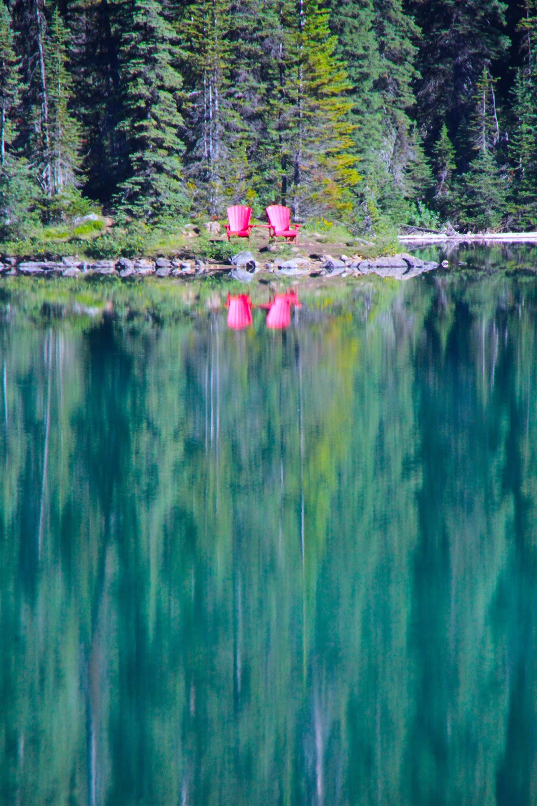
Takakkaw Falls is also home to two red Adirondack chairs as part of Parks Canada's Red Chair Program. The program is a neat way for visitor's to connect with nature and discover the best that Parks Canada has to offer. There are two sets of chairs in Yoho, the other being on the shoreline of Yoho Lake, which you can see on my Burgess Shale post.

The red chairs at Takakkaw Falls
You can read all about the Red Chair Program by visiting the Calgary Guardian website and reading my story titled, Share The Chair.

As I was driving back down the Yoho Valley Road I noticed Cathedral Mountain almost glowing from the setting sun
There are two other informative stops along the Yoho Valley Road (the road that leads to Takakkaw Falls), so I decided to stop at both on my way back to the campground as they were completely empty! The first is The Meeting of the Waters where the Kicking Horse and Yoho Rivers combine. The sign in the parking lot reads:
There is a marked contrast in the colour of these two merging rivers. The milky colouration of the Yoho River is caused by glacial silt from nearby glaciers. Glacial silt in the Kicking Horse River has settled out in a series of upstream lakes leaving clearer water.
Meeting of the Waters
The Kicking Horse River (top) is more of a bluish-white colour when compared with the siltier Yoho River (foreground)
Again it was nice to visit the site without dozens of people being around, but since the sun had set behind the mountains it was difficult to see the difference in water colour. I am assuming that during the day with the sun high overhead the distinct colour differences would be unmistakable.

Kicking Horse River
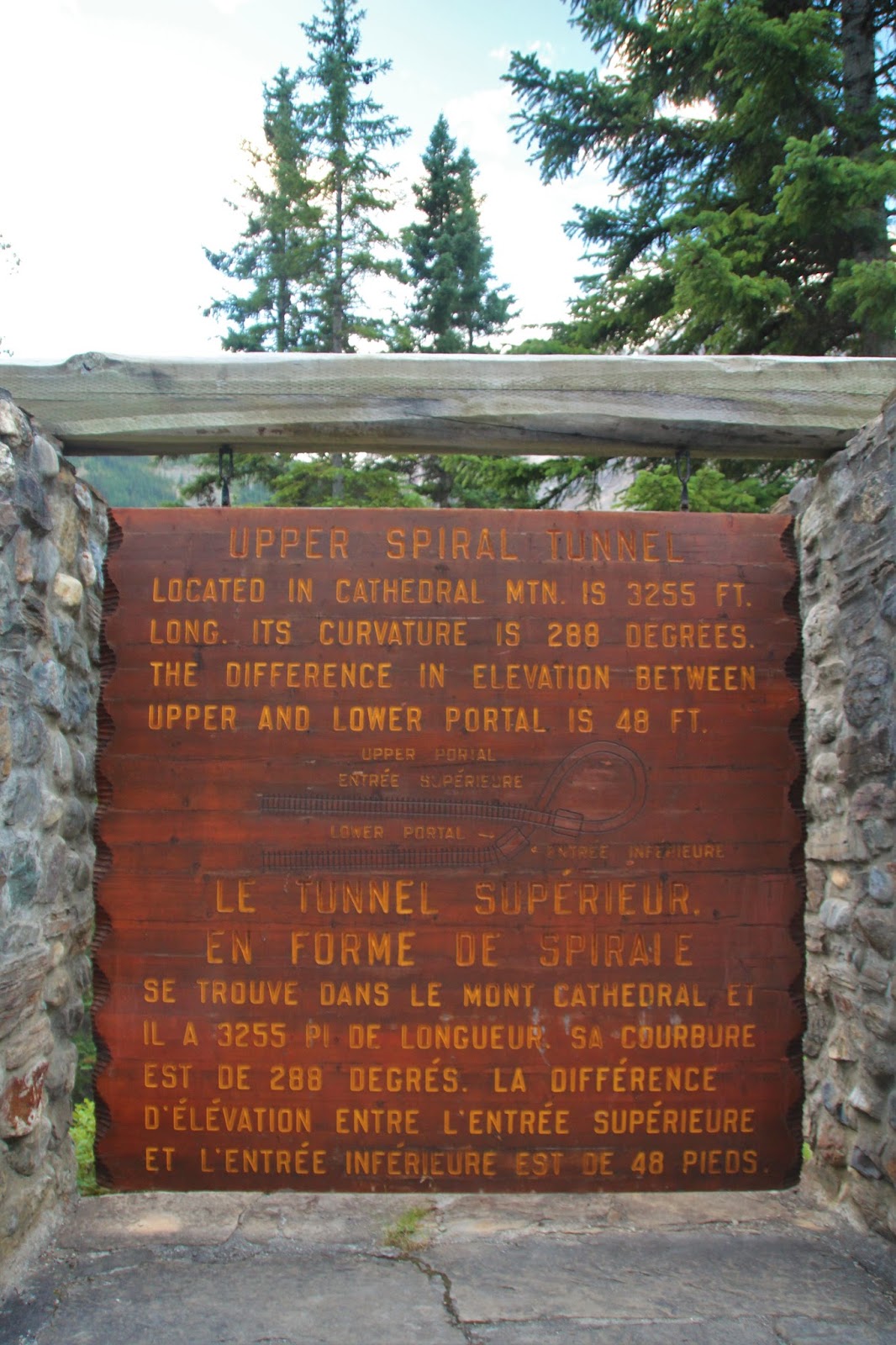
My final stop before calling it a night was the Upper Spiral Tunnel Viewpoint. The Spiral Tunnels are a marvel of engineering that reduced the grade of the difficult Kicking Horse Pass and allowed the railroad to continue its journey west. For reference the Lower Spiral Tunnel Viewpoint is located 7.5 km east of the town of Field along the Trans-Canada Highway. 

Upper Spiral Tunnel Viewpoint
I didn't time it right, but it would be neat to watch a train enter and exit the tunnels
Friday morning I was up at 5:45am in order to be at the trailhead by 7:00am to start the hike to Burgess Shale. We were on the trail for 10.5 hours so I wasn't back at the campground until early evening, which turned out to be perfect timing as Christine and Rome had pulled in 15 minutes before I did. We relaxed and cooked dinner before taking an evening drive up to Takakkaw Falls. Surprisingly our drive was filled with wildlife sightings including two female Elk with their calves, a White-Tailed Deer, a Porcupine, and a lone Moose. By adding that to my own sightings of Marmots, Golden-Mantled Ground Squirrels, Pika, a Golden Eagle, Columbian Ground Squirrels, and a Grizzly Bear this was shaping up to be a wildlife-filled weekend!

Considering this Elk was in the same spot as the previous night it might be the same one. The second female was close by.
One of the Elk calves
This second must be a little younger as it still had its spots
You don't get to see Porcupines very often. Glad I was able to get a quick photo!
Christine, Rome, and I had the place to ourselves again!
I was tired from my long hike so we called it a night pretty early. Unfortunately we were woken up around 2:30am by one of the loudest thunderstorms I can remember. I don't know if the storm was truly that loud of if it was just echoing off of the mountains, but it was incredibly hard to get back to sleep. Thankfully morning broke calm but cool with the sun burning off any last vestiges of the overnight storm. After breakfast we packed up the paddleboards and headed for Emerald Lake for some time on the water.

Stand-up paddleboarding on Emerald Lake
Rome enjoying the scenery
Christine taking Rome for a paddle
Rome didn't last very long on Christine's board. She spent most of the time crying and trying to get back over to me!
You can see the thunderstorm building on the left side of the photo
Heading for home as we didn't want to be caught on the water if/when the storm hit!
Our time on the water was perfect with blue skies and warm sunshine, but we could see the storms building. My mid-afternoon it was storming again so we took a drive up the Icefields Parkway thinking the storm might be isolated near Field. We were wrong and the storms only gained intensity as we drove north. We turned around and headed back to our campsite only to discover large piles of hail on the ground. I guess we had missed a bad storm while we were away and things weren't looking any better. The forecast was calling for sever thunderstorms for the the rest of the day, overnight, and the next day so we decided to pull the pin and head back to Calgary a day early. We packed up all of our wet gear, loaded the vehicles, and hit the highway. We were obviously disappointed with the weather, but were still happy we managed to get out for a few days.

It's easy to see why Yoho means 'awe and wonder' in the Cree language; it describes the park perfectly!

To read about my other forays into Yoho National Park please visit my previous blog posts titled, Yoho National Park and Emerald & Hamilton Lakes. You can also read the story I wrote about the Burgess Shale in several places including this blog post (Burgess Shale), the Calgary Guardian (Yoho's Stone Bugs), and GOT Parks (Yoho's Stone Bugs).